
اخبار العرب-كندا 24: الأربعاء 10 ديسمبر 2025 08:08 مساءً
Drivers beware: A storm is moving through Atlantic Canada and bringing diverse conditions across the Maritimes, potentially impacting travel into Thursday morning.
Be sure to monitor for updates and use caution on the roads.
"Roads and walkways will likely be difficult to navigate due to accumulating snow," warns Environment and Climate Change Canada (ECCC) in a snowfall warning issued for parts of New Brunswick. "Allow extra time for travel."

Baron - Atlantic Canada Wednesday overnight - Dec 10
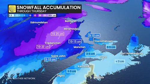
Northern and central New Brunswick may see 15-25 cm of snowfall, with Fredericton expected to receive approximately 20 cm.
RELATED: Freezing rain is the 'worst' type of precipitation. Here's why
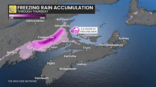
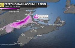
South and east of Fredericton, freezing rain lasting three to six hours could impact travel across Moncton and Saint John.
Baron - ATL freezing rain - Dec 10
Across P.E.I., between 5-10 cm of snow is expected, mixed with warmer air.
Advertisement
Advertisement
Advertisement
Advertisement
Nova Scotia is primarily forecast to receive rain during the event.

Baron - Atlantic Canada snow - Dec 10
Cold and blustery conditions across the Maritimes this weekend
Arctic air is set to return to the Maritimes on Friday, bringing blustery and cold conditions that will persist through the weekend. Expect flurries, snow showers, and sea-effect snow bands, though no major storms are anticipated.
The latter half of December appears changeable, with Arctic air from the west clashing with milder Atlantic air to the south. This pattern may result in significant systems, but it is too soon to determine storm tracks or impacts.
WATCH: Why freezing rain is the WORST type of precipitation
Click here to view the video
تم ادراج الخبر والعهده على المصدر، الرجاء الكتابة الينا لاي توضبح - برجاء اخبارنا بريديا عن خروقات لحقوق النشر للغير
