
اخبار العرب-كندا 24: الأربعاء 10 ديسمبر 2025 06:44 مساءً
A rather impactful atmospheric river has triggered a flood warning in British Columbia after bringing excessive rainfall totals to some areas.
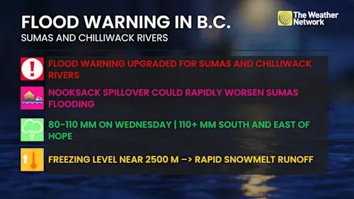
A flood warning has been issued for the Sumas and Chilliwack rivers, indicating flooding is imminent or occurring in these regions as a strong atmospheric river stalls near the Washington state-B.C. border.
DON’T MISS: Atmospheric rivers becoming so intense we need to rank them like hurricanes
Flooding is expected or imminent, with a multi-river, flood-risk event. Ten- to 20-year flood levels are expected by late Wednesday or early Thursday.
Advertisement
Advertisement
Advertisement
Advertisement
Water will likely pool on roads and in low-lying areas. Visibility will likely be suddenly reduced at times. Don't drive through flooded roadways.
Flood warnings issued as river levels rise after heavy rainfall
Heaviest rain is ongoing through early Wednesday evening for the Fraser Valley, with torrential pockets of rain still occurring.

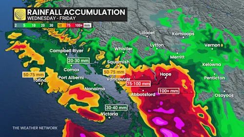
B.C. rainfall totals through Wednesday morning
The highest total so far recorded on Wednesday is 56 mm in Cultus Lake and 60 mm in Hope.
Highest rainfall reports through Wednesday morning
-
Port Mellon: 111 mm
-
Hope: 105 mm
-
Coquitlam (Burke Mountain): 101 mm
-
Squamish: 83 mm
-
Port Alberni: 66 mm
-
North Cowichan: 55 mm
-
Victoria: 54 mm
By Thursday, the stream of moisture slumps south, with showers dissipating through the morning.

B.C. rainfall accumulation through Friday
Flood warning
-
Sumas River (including potential Nooksack River spillover). The current forecast is below 2021, but still a low likelihood scenario if rainfall exceeds forecasts.
-
Chilliwack River, Coquihalla, Skagit and Lower Fraser tributaries. Impacts focused on Abbotsford, Chilliwack, Hope and areas east toward Manning Park.
DON'T MISS: Here are Canada's worst winter roads and the riskiest times to drive
B.C. flood warning
This confirms flooding is expected or imminent, with a multi-river, flood-risk event. Ten- to 20-year flood levels are expected by late Wednesday into early Thursday.
Advertisement
Advertisement
Advertisement
Advertisement
Also an issue is the Nooksack River flood risk rising in Washington state. There is a 13 per cent chance of an exceeding flood spill threshold. It could push floodwaters into the Sumas River system.
Once again, heavy snow targets the Interior mountain passes through Wednesday.
-
Rogers Pass: 20-40 cm
-
Kootenay Pass (Highway 3--Paulson Summit to Kootenay Pass): up to 10 cm
-
Okanagan Connector Summit (Merritt-Kelowna): up to 10 cm
Long-range outlook looking very active and mild
An active pattern with above-normal precipitation totals is expected though Christmas.
Very mild temperatures will continue to dominate for the next week with high freezing levels, but the pattern should trend colder (near seasonal) by the middle of or late next week, and colder-than-normal temperatures are possible during the week leading up to Christmas--something that is desperately by the ski areas.
Stay with The Weather Network for the latest on conditions across British Columbia.
WATCH: Canada is getting its own atmospheric river rating scale
Click here to view the video
تم ادراج الخبر والعهده على المصدر، الرجاء الكتابة الينا لاي توضبح - برجاء اخبارنا بريديا عن خروقات لحقوق النشر للغير
