


اخبار العرب-كندا 24: الثلاثاء 9 ديسمبر 2025 09:08 مساءً
The next B.C. atmospheric river will pack a wallop, expected to produce high rainfall totals across the Lower Mainland and the Fraser Valley.
Totals since Sunday have topped 70 mm in portions of the South Coast; the next round of torrential rainfall threatens over 100 mm across the Fraser Valley, further increasing the threat of localized flooding.
DON’T MISS: Atmospheric rivers becoming so intense we need to rank them like hurricanes

B.C. atmospheric river, Dec. 8, 2025
On Wednesday, there’s more concern for more intense, high-elevation snow across eastern B.C. We have an additional 10-20+ cm forecast across higher terrain.
Advertisement
Advertisement
Advertisement
Advertisement
With that, expect hazardous travel along the mountain passes as they face copious amounts of snowfall.
Heavy rain, snow continues as next atmospheric river pushes through
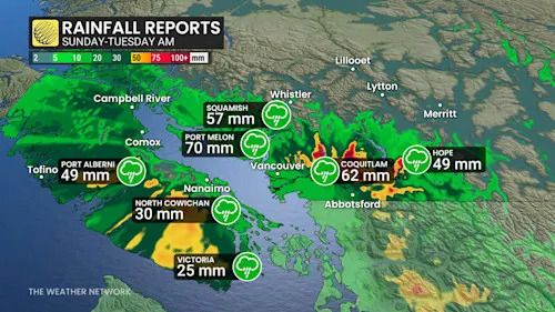
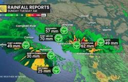
Highest rainfall reports through Tuesday morning include:
-
Port Mellon: 70 mm
-
Coquitlam: 62 mm
-
Squamish: 57 mm

B.C. rainfall reports Sunday to Tuesday
By Tuesday night, the next wave of moisture arrives across the South Coast, producing rainfall rates up to 3-5 mm an hour as the atmospheric river stalls in the eastern Fraser Valley and Washington state on Wednesday.
Rainfall totals with the next wave will likely reach upwards of 40-50 mm for downtown Vancouver and 75-100+mm for the eastern Fraser Valley. Greater Victoria is likely recording 30-50 mm of rainfall.
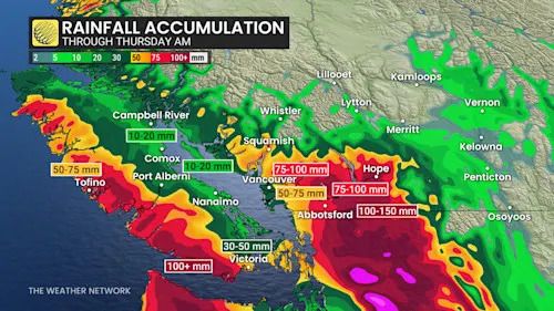
B.C. rainfall through Thursday morning
By Thursday, the stream of moisture slumps south, with showers dissipating through the morning.
Advertisement
Advertisement
Advertisement
Advertisement
Once again, heavy snow targets the Interior mountain passes through Wednesday.
-
Pine Pass: 20-30 cm
-
Rogers Pass (Trans-Canada Highway): up to 20 cm
-
Kootenay Pass/Paulson Summit: up to 20 cm

B.C. mountain pass snowfall through Wednesday
Flood risk
The peak flood risk is expected late Wednesday into Thursday. Fraser Valley rivers could reach five- to 10-year flood levels, or higher. The main impacts include riverbank erosion, submerged roads and an elevated landslide risk.
-
Flood watch: Lower Fraser and Skagit
-
Chilliwack, Skagit, Coquihalla Rivers
-
Abbotsford, Chilliwack, Hope
-
East through Manning Park
-
The Sumas River is also at risk due to possible Nooksack River spillover
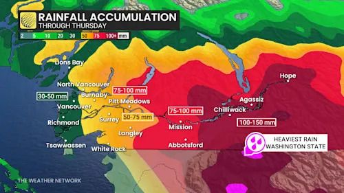
South Coast rainfall through Thursday
WATCH: Atmospheric river brings torrential rain and flood risk to Vancouver Island
Click here to view the video
High streamflow advisories
-
Tulameen River
-
Coldwater River
-
Central Coast (Kingcome, Wannock)
-
South Coast, including Metro Vancouver and North Shore
-
Vancouver Island
DON'T MISS: Here are Canada's worst winter roads and the riskiest times to drive
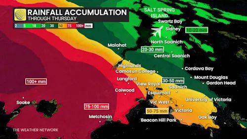
Greater Victoria rainfall accumulation through Thursday
Also an issue is the Nooksack River flood risk rising in Washington state. There is a 13 per cent chance of an exceeding flood spill threshold. It could push floodwaters into the Sumas River system.
Advertisement
Advertisement
Advertisement
Advertisement
Luckily, a dry pattern over the past week will give some breathing room for the watershed.
Long-range outlook looking very active and mild
Beyond, above-seasonal temperature will continue to dominate across southern B.C. through mid-December, and passed that. No persistent, frigid weather is in sight.

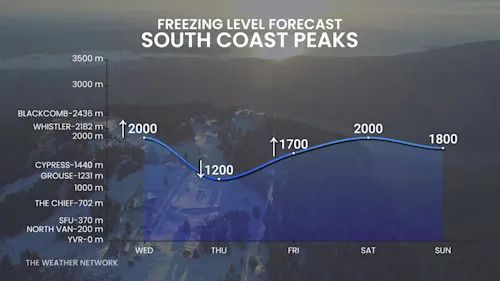
B.C. freezing levels South Coast this week
A very active pattern will continue for the South Coast region well into the second half of December, with above-normal precipitation totals. Very heavy snow is forecast for the alpine regions, but snow levels will often be on the high side of normal with rain at the bases of the ski areas.
Stay with The Weather Network for the latest on conditions across British Columbia.
WATCH: Canada is getting its own atmospheric river rating scale
Click here to view the video
تم ادراج الخبر والعهده على المصدر، الرجاء الكتابة الينا لاي توضبح - برجاء اخبارنا بريديا عن خروقات لحقوق النشر للغير
