


اخبار العرب-كندا 24: الخميس 4 ديسمبر 2025 11:44 صباحاً
British Columbia is entering an active weather pattern through mid-December, with above-normal precipitation expected across the province, including the South Coast.
Over the next five days, B.C. will see increased rainfall, significant alpine snow accumulation, and an atmospheric river event Sunday into Monday.

Baron - BC atmospheric moisture - Monday Dec 8
Above seasonal temperatures will dominate across most of the province through next week, but arctic air will spread into northern and northeastern areas, and attempt to spread south as we progress through mid-December.
DON'T MISS: Canada’s December outlook holds a strong, cold start to winter
Rounds of rain, snow, and wind to impact B.C. through the weekend and early next week
A low pressure system over the Gulf of Alaska will usher multiple weather systems onto B.C.’s coast, bringing waves of rain, snow, and gusty winds through the weekend into early next week.
Advertisement
Advertisement
Advertisement
Advertisement
After a wet Thursday, southern coastal areas will see increased rainfall beginning overnight Thursday into early Friday.
RELATED: Atmospheric Rivers: Expert explains the good and bad of these extreme storms
Widespread snow will impact the southern interior, with freezing levels near 1200 metres. Snow will spread into the interior and Rockies by Friday afternoon. Coastal ski resorts like Whistler Blackcomb, Sun Peaks, and SilverStar could receive 10-20 cm of snow.
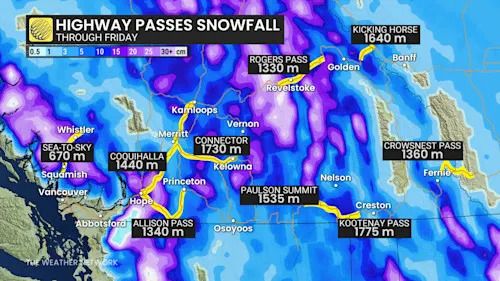
Baron - BC Highway Pass snowfall - Dec 4
Fresh snowfall will benefit the ski areas, but road conditions may pose travel challenges.
Precipitation will ease Saturday night before picking up again early Sunday as a surge of moisture delivers steady rain to the coast and additional snow to the coastal mountains.

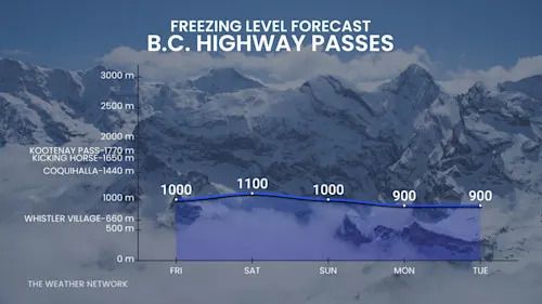
Baron - BC Freezing level forecast highway passes - Dec 4
Freezing levels will range from 1000-1200 metres along the coast and dip below 1000 metres in interior mountain ranges such as the Cariboo, Selkirk, and Purcell regions.
Risk of localized flooding early next week
This storm pattern could bring heavy rainfall Monday into Tuesday, increasing the risk of localized flooding and pooling on roads.
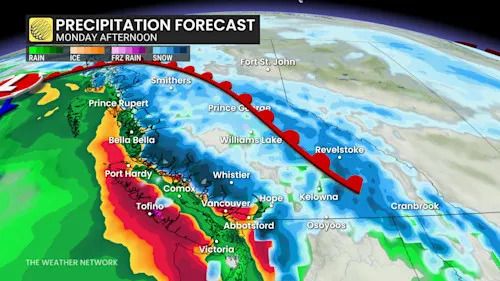
Baron - BC precipitation Monday afternoon - Dec 4
Travelers should prepare for challenging conditions, as passes will see accumulating snow and gusty winds reaching up to 60 km/h.
SEE ALSO: More dangerous than snow: Why driving in the rain can be a bigger hazard
Coastal areas may also see strong wind gusts Monday as fronts move inland.
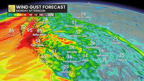
Baron - BC winds Monday afternoon - Dec 4
Advertisement
Advertisement
Advertisement
Advertisement
WATCH: What is an 'Atmospheric River?'
Click here to view the video
Be sure to check back for the latest weather updates from B.C.
تم ادراج الخبر والعهده على المصدر، الرجاء الكتابة الينا لاي توضبح - برجاء اخبارنا بريديا عن خروقات لحقوق النشر للغير