
اخبار العرب-كندا 24: الأربعاء 27 مارس 2024 07:27 صباحاً
This week will see a complex storm bring a mix of wintry and spring impacts to a good portion of Quebec and the East Coast.
An icy system will move into Eastern Canada Wednesday, bringing freezing rain into northern Quebec and parts of northern New Brunswick, while the southern Maritimes deals with prolonged rain and the threat of localized and river flooding.
RELATED: Storm washes out roads, leaves thousands in New Brunswick without power
Brace for difficult travel, power outages and localized flooding with the storm. Ensure your devices are charged and consider postponing travel during the peak of the storm as roads will be slippery or feature ponding.

Freezing rain warnings are in place for parts of Quebec and New Brunswick Wednesday morning. Freezing rain warnings are issued when rain falling in sub-zero temperatures creates ice buildup and icy surfaces.
Also, Maritimers can expect rounds of rain to last well into the Easter weekend, with cool and blustery conditions settling in behind the storm system.
Wednesday: Icy system tracks in, risk of difficult travel and outages
Showers will begin Wednesday across the southern Maritimes, with icy precipitation picking up across northern New Brunswick and Quebec's Gaspé Peninsula as temperatures remain cooler.
Quebec's North Shore will see freezing rain move in by the noon hour. The icy precipitation then changes to rain in northern New Brunswick and Gaspé through the late morning. Precipitation rates will intensify through the day in the northern Maritimes. The freezing rain and rain threat creeps into parts of western Newfoundland for a few hours on Wednesday, as well.
DON'T MISS: Eclipse viewing parties in Quebec are coming to a path of totality near you
Between 5-15 mm of ice accretion is possible for the hardest-hit spots, which could bring slippery road, walkway and parking lot conditions and localized power outages. So ensure devices are charged and consider modifying travel plans.
Story continues
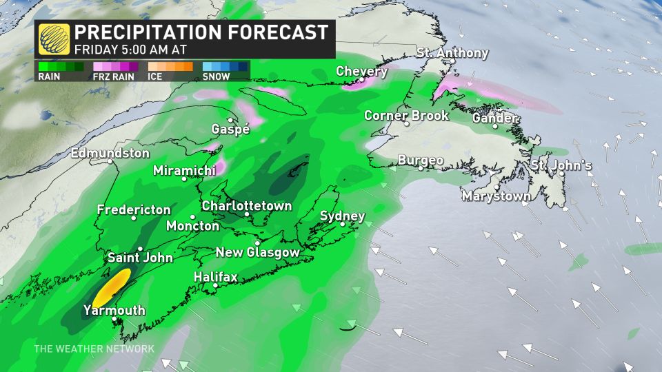
Thursday into the weekend: Days of heavy rain span the southern Maritimes
The icy precipitation will eventually be replaced by straight rain, with bands of locally heavy rain expected across the Maritimes for the next several days. That's as two moisture streams, one from the tropics and another from the Gulf of Mexico, collide over Atlantic Canada.
The widespread soaking rain and blustery conditions will persist well into the Easter weekend.
The heaviest rainfall will be near the Bay of Fundy, and parts of southwestern Nova Scotia, with between 50-100+ mm possible. The rainfall will become more widespread on Friday and Saturday, as a very soggy system slides over Atlantic Canada during the weekend.
DON'T MISS: Everything you need to know for April's spectacular and rare solar eclipse
Risk for flooding
It should be noted that the placement of heaviest rain totals could shift, but certainty is increasing for rising river levels, which could come close to hitting the flood stage in some areas.
There's a heightened flood concern across Nova Scotia and southern New Brunswick, especially with unstable soils from recent rains and high moisture.
An important area to watch for potential flooding is around the lower Saint John River. Due to ice jams and their unpredictable nature, it's hard to tell what the river levels will be like between Perth-Andover and Woodstock with this rainfall event.
River levels are forecast to reach a critical threshold around Nashwaak and Durham Bridge in the coming days, so be sure to regularly check for public alerts and advisories if you are in this area.
Localized flooding is also possible in areas with poor drainage. As well, there is a good chance of ponding or pooling on the roadways, so be aware if you're planning on travelling. Remember to never drive through flooded or washed-out roadways, as this could cause your vehicle to stall and put you in a dangerous situation.

A band of significant snow is expected to develop on the back side of the storm, possibly impacting eastern Quebec and parts of the Maritimes, though the track of the system and its exact impacts are still uncertain.
Conditions will remain blustery and cool, with yet another system eyeing the region for the middle of next week.
WATCH BELOW: New pilot program uses batteries to keep power on during a storm
Click here to view the video
Be sure to check back for the latest updates across Eastern Canada this week.
تم ادراج الخبر والعهده على المصدر، الرجاء الكتابة الينا لاي توضبح - برجاء اخبارنا بريديا عن خروقات لحقوق النشر للغير


