تسجيل دخول
تسجيل
أخبار عاجلة
Concert ticket system is 'broken,' say artists. But some experts say targeting resellers isn't the fix
-
الجمعة 26 أبريل 2024 06:30 مساءً
OPP reviewing interaction between officer, protesters outside Trudeau event
-
الجمعة 26 أبريل 2024 06:23 مساءً
احتجاجات الجامعات الأميركية تتوسع دعما لغزة وانضمام جامعتين جديدتين
-
الجمعة 26 أبريل 2024 06:10 مساءً
ليستر سيتي يعود للدوري الإنجليزي الممتاز
-
الجمعة 26 أبريل 2024 06:08 مساءً
شاهد.. الأهلي يواجه الترجي في "نهائي عربي خالص" لدوري أبطال أفريقيا
-
الجمعة 26 أبريل 2024 06:08 مساءً
العراق المنتخب العربي الوحيد بنصف نهائي كأس آسيا تحت 23 عاما
-
الجمعة 26 أبريل 2024 06:08 مساءً
المقاومة الإسلامية في العراق تستهدف "هدفا حيويا" في حيفا
-
الجمعة 26 أبريل 2024 06:08 مساءً
بايدن يرحب بالمناظرة وترامب يقترح "الليلة في قاعة المحكمة"
-
الجمعة 26 أبريل 2024 06:08 مساءً
عائلات الأسرى تتظاهر أمام منزل غانتس ونتنياهو متهم بعرقلة صفقة التبادل
-
الجمعة 26 أبريل 2024 06:08 مساءً
أبرزها بالمغرب.. مظاهرات بمدن عربية وغربية دعما للفلسطينيين في غزة
-
الجمعة 26 أبريل 2024 06:08 مساءً
الرئيسية Home
العالم والعرب
العالم من حولنا
العالم العربي
الجالية ودليل المهاجر
أخبار الجالية
دليل المهاجر والمقيم
أقلام:المهجر
أقلام:الوطن
شعراء/وكتاب
كندا وامريكا/ملفات
اخبار كندا وامريكا
ملفات ساخنة
تكنولوجيا
ثقافة وفن
الاسرة والصحة/منوعات/حوادث
الصحة
منوعات
حوادث عربية وعالمية
أسواق واعمال
الشركات
الاقتصاد
الرياضة
للاعلان Advertising
موقعنا English Site
أسعار النفط تتجه لإنهاء سلسلة خسائر استمرت أسبوعين
محرر شؤون العالم-RT :
الجمعة 26 أبريل 2024 12:44 صباحاً
دراسة تكشف "سببا غريبا" يعيق نمو الطيور
محرر شؤون العالم-RT :
الجمعة 26 أبريل 2024 12:44 صباحاً
استطلاع رأي يكشف: كيف ينظر الأميركيون إلى نتنياهو؟
محرر شؤون العالم-RT :
الجمعة 26 أبريل 2024 12:44 صباحاً
فضيحة فساد في موسكو.. تفاصيل القبض على نائب وزير الدفاع
محرر شؤون العالم-RT :
الجمعة 26 أبريل 2024 12:44 صباحاً
غزة.. استئصال ورم ضخم لمريض بالمستشفى الميداني الإماراتي
محرر شؤون العالم-RT :
الجمعة 26 أبريل 2024 12:44 صباحاً
العالم والعرب ٠٠٠٠٠٠٠٠٠٠٠٠٠٠٠٠٠٠٠٠٠٠٠٠٠٠٠٠٠٠٠٠٠٠٠٠٠٠٠٠٠٠٠٠٠٠٠٠٠٠٠٠٠٠٠٠٠٠٠٠٠٠٠٠٠٠٠٠٠٠٠
العالم من حولنا
احتجاجات الجامعات الأميركية تتوسع دعما لغزة وانضمام جامعتين جديدتين
اعداد اسمهان الجزيرة :
الجمعة 26 أبريل 2024 06:10 مساءً
ليستر سيتي يعود للدوري الإنجليزي الممتاز
العالم من حولنا
اعداد اسمهان الجزيرة :
الجمعة 26 أبريل 2024 06:08 مساءً
شاهد.. الأهلي يواجه الترجي في "نهائي عربي خالص" لدوري أبطال أفريقيا
العالم من حولنا
اعداد اسمهان الجزيرة :
الجمعة 26 أبريل 2024 06:08 مساءً
العراق المنتخب العربي الوحيد بنصف نهائي كأس آسيا تحت 23 عاما
العالم من حولنا
اعداد اسمهان الجزيرة :
الجمعة 26 أبريل 2024 06:08 مساءً
العالم من حولنا
المقاومة الإسلامية في العراق تستهدف "هدفا حيويا" في حيفا
اعداد اسمهان الجزيرة :
الجمعة 26 أبريل 2024 06:08 مساءً
بايدن يرحب بالمناظرة وترامب يقترح "الليلة في قاعة المحكمة"
العالم من حولنا
اعداد اسمهان الجزيرة :
الجمعة 26 أبريل 2024 06:08 مساءً
عائلات الأسرى تتظاهر أمام منزل غانتس ونتنياهو متهم بعرقلة صفقة التبادل
العالم من حولنا
اعداد اسمهان الجزيرة :
الجمعة 26 أبريل 2024 06:08 مساءً
أبرزها بالمغرب.. مظاهرات بمدن عربية وغربية دعما للفلسطينيين في غزة
العالم من حولنا
اعداد اسمهان الجزيرة :
الجمعة 26 أبريل 2024 06:08 مساءً
اخبار الجالية ودليل المهاجر ٠٠٠٠٠٠٠٠٠٠٠٠٠٠٠٠٠٠٠٠٠٠٠٠٠٠٠٠٠٠٠٠٠٠٠٠٠٠٠٠٠٠٠٠٠٠٠٠٠٠٠٠٠٠٠٠٠٠٠٠٠٠
اخبار الجالية
مقتل طالب أجنبي رميا بالرصاص في فانكوفر
canadanews24.ca:
الأحد 14 أبريل 2024 03:20 مساءً
الحكومة الكندية تصدر تحذيرات من السفر إلى هذه الوجهات السياحية الشهيرة
اخبار الجالية
canadanews24.ca:
الأحد 14 أبريل 2024 02:45 مساءً
الدولار الكندي يسجل أكبر انخفاض أسبوعي في 11 شهرا
اخبار الجالية
canadanews24.ca:
الأحد 14 أبريل 2024 01:45 مساءً
شرطة تورنتو تنشر صورا لمشتبه به في حادثة اعتداء جنسي على امرأتين في محطة المترو
اخبار الجالية
canadanews24.ca:
الأحد 14 أبريل 2024 01:45 مساءً
اخبار الجالية
حزب كيبيك يدعو إلى تجميد الهجرة المؤقتة
canadanews24.ca:
الأحد 14 أبريل 2024 12:58 مساءً
الآلاف في أونتاريو لا يزالون دون كهرباء بعد أن تسببت الرياح العاتية في انقطاع التيار
اخبار الجالية
canadanews24.ca:
الأحد 14 أبريل 2024 12:37 مساءً
النمو السكاني في ألبرتا يحطم الأرقام القياسية.. ولكن هناك أنباء سيئة للمهاجرين
اخبار الجالية
canadanews24.ca:
الأحد 14 أبريل 2024 12:25 مساءً
كندا ودول مجموعة السبع الأخرى تعقد اجتماعا لمناقشة الرد المحتمل على الهجوم الإيراني على إسرائيل
اخبار الجالية
canadanews24.ca:
الأحد 14 أبريل 2024 12:03 مساءً
أقلام من المهجر.................................................................................................
اقلام من المهجر
الحياة علمتنى/ مذكرات مهاجـــــــــــرة :بقلم /مادلين بدوي—نورث يورك
الأحد 11 أكتوبر 2020 10:00 مساءً
أقلام من الوطن ..................................................................................................
شعراء/ ومعارض الكتب ............................................................................................
شعراء/ وكتاب
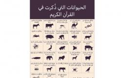
معجزات وحكم في كتاب "قصص الحيوان في القرآن" بقلم أحمد بهجت
ملفات اخبار العرب24-كندا:
السبت 13 أبريل 2024 06:58 صباحاً
دور الصلاة في حياتنا في "كيمياء الصلاة" بقلم أحمد خيري العمري
شعراء/ وكتاب
ملفات اخبار العرب24-كندا:
الأربعاء 10 أبريل 2024 07:19 صباحاً
اقرأ معنا كتاب "مائة سؤال في الدراما" بقلم ياسر عيسى الياسري
شعراء/ وكتاب
ملفات اخبار العرب24-كندا:
الثلاثاء 09 أبريل 2024 07:00 صباحاً
سرقة 1800 قطعة من المتحف البريطاني في لندن
شعراء/ وكتاب
ملفات اخبار العرب24-كندا:
الاثنين 08 أبريل 2024 07:20 صباحاً
شعراء/ وكتاب
إغلاق باب التسجيل لجائزة محمد بن راشد للغة العربية الدورة 8
ملفات اخبار العرب24-كندا:
الاثنين 08 أبريل 2024 07:20 صباحاً
فوزية السندي الشخصية الثقافية للشارقة لإبداعات المرأة الخليجية
شعراء/ وكتاب
ملفات اخبار العرب24-كندا:
الاثنين 08 أبريل 2024 07:20 صباحاً
أقدم مخطوطة مكتوبة باللغة القبطية للبيع في دار كريستي
شعراء/ وكتاب
ملفات اخبار العرب24-كندا:
الجمعة 05 أبريل 2024 12:02 صباحاً
مكتبة محمد بن راشد تنظم فعاليات و مبادرات في شهر القراءة
شعراء/ وكتاب
ملفات اخبار العرب24-كندا:
الثلاثاء 02 أبريل 2024 11:44 مساءً
كندا وامريكا/ملفات ٠٠٠٠٠٠٠-٠٠٠-٠-٠٠٠٠٠٠٠٠٠٠٠٠-٠٠٠٠٠٠٠٠٠٠٠٠٠٠٠٠٠٠٠٠٠٠٠٠٠٠٠٠٠٠٠٠٠٠٠٠٠٠٠٠٠٠
كندا وامريكا/ملفات
Concert ticket system is 'broken,' say artists. But some experts say targeting resellers isn't the fix
متابعة اسمهان ملاك: ر. كندا الدولي:
الجمعة 26 أبريل 2024 06:30 مساءً
OPP reviewing interaction between officer, protesters outside Trudeau event
كندا وامريكا/ملفات
متابعة اسمهان ملاك: ر. كندا الدولي:
الجمعة 26 أبريل 2024 06:23 مساءً
Charge dropped for man accused of flying 'terrorist flag'
كندا وامريكا/ملفات
متابعة اسمهان ملاك: ر. كندا الدولي:
الجمعة 26 أبريل 2024 05:48 مساءً
Toronto police constable charged with perjury
كندا وامريكا/ملفات
متابعة اسمهان ملاك: ر. كندا الدولي:
الجمعة 26 أبريل 2024 05:17 مساءً
كندا وامريكا/ملفات
Ex-youth worker endured 'shameful self-reflection' after sexual exploitation of 14-year-old
متابعة اسمهان ملاك: ر. كندا الدولي:
الجمعة 26 أبريل 2024 04:59 مساءً
Business Matters: Loblaw and Walmart have refused to sign Canada's grocery code of conduct, documents show
كندا وامريكا/ملفات
متابعة اسمهان ملاك: ر. كندا الدولي:
الجمعة 26 أبريل 2024 04:59 مساءً
China to host Hamas, Fatah for Palestinian unity talks
كندا وامريكا/ملفات
متابعة اسمهان ملاك: ر. كندا الدولي:
الجمعة 26 أبريل 2024 04:05 مساءً
Public inquest scheduled in death of 14-year-old who drowned in Regina creek in 2015
كندا وامريكا/ملفات
متابعة اسمهان ملاك: ر. كندا الدولي:
الجمعة 26 أبريل 2024 03:13 مساءً
كندا وامريكا/ملفات
Trans Mountain expansion requires six more leave-to-open permits, regulator says
متابعة اسمهان ملاك: ر. كندا الدولي:
الجمعة 26 أبريل 2024 03:13 مساءً
Loblaws boycott picks up steam as resentment grows online
كندا وامريكا/ملفات
متابعة اسمهان ملاك: ر. كندا الدولي:
الجمعة 26 أبريل 2024 02:36 مساءً
Child hit by transport truck in Etobicoke, hospitalized
كندا وامريكا/ملفات
متابعة اسمهان ملاك: ر. كندا الدولي:
الجمعة 26 أبريل 2024 02:26 مساءً
Quebec man pleads guilty for role in scam to bilk thousands from Saskatoon seniors
كندا وامريكا/ملفات
متابعة اسمهان ملاك: ر. كندا الدولي:
الجمعة 26 أبريل 2024 02:06 مساءً
تكنواوجيا ٠٠٠٠٠٠-٠٠٠٠٠٠٠٠٠٠٠٠-٠٠٠٠٠٠٠٠٠٠٠٠٠٠٠٠٠٠٠٠٠٠٠٠٠٠٠٠٠٠٠٠٠٠٠٠٠٠٠٠٠٠٠٠٠٠٠٠٠٠٠٠٠٠
الأسرة والصحة/ منوعات/حوادث ٠٠٠٠٠٠-٠٠٠٠٠٠٠٠٠٠٠٠٠٠٠٠٠٠-٠٠٠٠٠٠٠٠٠٠٠٠٠٠٠٠٠٠٠٠٠٠٠٠٠٠٠٠٠٠٠٠٠٠
الاسواق والاعمال ٠٠٠٠٠٠٠٠٠٠٠٠٠٠٠٠٠٠٠٠٠٠٠٠٠٠٠٠٠٠٠٠٠٠٠٠٠٠٠٠٠٠٠٠٠٠٠٠٠٠٠٠٠٠٠٠٠٠٠٠٠٠٠٠٠٠٠٠
الأسواق والمال
بيان من قصر باكنغهام بشأن عودة الملك تشارلز لمهامه العامة
محرر شؤون العالم-RT :
الجمعة 26 أبريل 2024 01:57 مساءً
الغيص: الأمر يتعلق بخفض الانبعاثات لا الطلب على النفط
الأسواق والمال
محرر شؤون العالم-RT :
الجمعة 26 أبريل 2024 01:57 مساءً
تحديث بشأن التحقيق حول مشاركة موظفين بالأونروا في هجوم حماس
الأسواق والمال
محرر شؤون العالم-RT :
الجمعة 26 أبريل 2024 01:57 مساءً
ارتفاع سعر النّحاس إلى 10 آلاف دولار للطن لأول مرة منذ عامين
الأسواق والمال
محرر شؤون العالم-RT :
الجمعة 26 أبريل 2024 01:57 مساءً
الأسواق والمال
رئيس COP28 يدعو كافة الدول إلى تعزيز خططها للعمل المناخي
محرر شؤون العالم-RT :
الجمعة 26 أبريل 2024 01:57 مساءً
تقرير يحذر من انتشار "مقلق" لهذا السلاح في الشرق الأوسط
الأسواق والمال
محرر شؤون العالم-RT :
الجمعة 26 أبريل 2024 01:57 مساءً
زيلينسكي يطالب أميركا بالمزيد من أنظمة الدفاع الجوي
الأسواق والمال
محرر شؤون العالم-RT :
الجمعة 26 أبريل 2024 01:57 مساءً
مسؤول تركي: أردوغان يرجئ زيارته للبيت الأبيض
الأسواق والمال
محرر شؤون العالم-RT :
الجمعة 26 أبريل 2024 01:57 مساءً
ثقافة وفن ٠٠٠٠٠-٠٠٠٠٠٠٠٠٠٠٠٠٠٠-٠٠٠٠٠٠٠٠٠٠٠٠٠٠٠٠٠٠٠٠٠٠٠٠٠٠٠٠٠٠٠٠٠٠٠٠٠٠٠٠٠٠٠٠٠٠٠٠٠٠٠٠٠
ثقافة وفن
محمد الأحمد: من حلاق نسائي لـ ممثل.. وأبوطلحة الداعشي بداية انتشاره عربيًا
ملفات اخبار العرب24-كندا:
الأربعاء 17 أبريل 2024 08:07 صباحاً
آريانا غراندي تتحدث العربية بطلاقة.. وجدتها تدخل التاريخ
ثقافة وفن
ملفات اخبار العرب24-كندا:
الأربعاء 17 أبريل 2024 08:07 صباحاً
هل سخر جيم يلماز من جسد حبيبته السابقة سيريناي سيركايا؟
ثقافة وفن
ملفات اخبار العرب24-كندا:
الأربعاء 17 أبريل 2024 08:07 صباحاً
إطلالة عمرو دياب في عيد الفطر تثير الجدل.. أكثر من ربع مليون دولار
ثقافة وفن
ملفات اخبار العرب24-كندا:
الأربعاء 17 أبريل 2024 08:07 صباحاً
ثقافة وفن
صورة كريم بنزيما مع فنانة هندية تثير الجدل.. ارفقت الصورة بتعليق "الحب"
ملفات اخبار العرب24-كندا:
الأربعاء 17 أبريل 2024 08:07 صباحاً
الدكتورة خلود للساخرين من شكل أذنيها: "اشبعي منهم يلا"
ثقافة وفن
ملفات اخبار العرب24-كندا:
الأربعاء 17 أبريل 2024 08:07 صباحاً
ريهام حجاج تتصدر التريند بعد تصريحها: (مش كل الناس اتفقت على ربنا!)
ثقافة وفن
ملفات اخبار العرب24-كندا:
الأربعاء 17 أبريل 2024 08:07 صباحاً
نقل عبير صبري للمستشفى و شقيقتها تكشف عن وضعها الصحي
ثقافة وفن
ملفات اخبار العرب24-كندا:
الأربعاء 17 أبريل 2024 08:07 صباحاً
الرياضة ٠٠٠٠٠٠٠٠٠٠٠٠٠٠٠٠٠٠٠٠٠٠٠٠٠٠٠٠٠٠٠٠٠٠٠٠٠٠٠٠٠٠٠٠٠٠٠٠٠٠٠٠٠٠٠٠٠٠٠٠٠٠٠٠٠٠٠٠٠٠٠٠٠٠
الرياضة
متابعة: "متنكد" بسبب مباراة الهلال.. أمير سعودي يرد على صورة رصدته بالمدرج ويعلق على المباراة
سى ان ان
الخميس 25 أبريل 2024 02:20 صباحاً
متابعة: بعد مباراة الهلال والعين.. مشاري العفاسي يشتكى من "التعصب الرياضي" ويؤكد: لم أتابعها
الرياضة
سى ان ان
الأربعاء 24 أبريل 2024 07:39 صباحاً
متابعة: مانشستر سيتي يوجه رسالة إلى العين بعد بلوغه نهائي دوري أبطال آسيا على حساب الهلال
الرياضة
سى ان ان
الثلاثاء 23 أبريل 2024 11:08 مساءً
متابعة: موقف "طريف" بين مالكوم وبندر الأحبابي خلال مباراة الهلال والعين
الرياضة
سى ان ان
الثلاثاء 23 أبريل 2024 05:01 مساءً
الرياضة
متابعة: إريك تين هاغ "يهاجم" الصحفيين ومنتقدي أداء مانشستر يونايتد: تعليقاتكم "وصمة عار"
سى ان ان
الثلاثاء 23 أبريل 2024 11:08 صباحاً
متابعة: جود بيلينغهام يكشف عن أسباب نجاحه مع ريال مدريد بهذه السرعة..هذا ما قاله
الرياضة
سى ان ان
الثلاثاء 23 أبريل 2024 08:37 صباحاً
متابعة: في "ديربي الغضب".. إنتر يحسم لقب الدوري الإيطالي لصالحه على حساب غريمه ميلان
الرياضة
سى ان ان
الاثنين 22 أبريل 2024 05:16 مساءً
متابعة: ميدو يُشبه الهلال في السعودية بالأهلي في مصر: "محدش يقدر يعمل حاجة تخصه دون الرجوع إليه"
الرياضة
سى ان ان
الاثنين 22 أبريل 2024 06:07 صباحاً
اعلانات الموقع- Our Site Ads- Call us at: (416)362-0304/Email: arabnews_ca@yahoo.ca ...............
اعلانك معنا يصل الى الجميع
2024 ©
c 1976-2021 Arab News 24 Int'l - Canada: كافة حقوق الموقع والتصميم محفوظة لـ أخبار العرب-كندا
الآراء المنشورة في هذا الموقع، لا تعبر بالضرورة علي آراء الناشرأو محرري الموقع ولكن تعبر عن رأي كاتبيها
Opinion in this site does not reflect the opinion of the Publisher/ or the Editors, but reflects the opinion of its authors.
This website is Educational and Not for Profit to inform & educate the Arab Community in Canada & USA
This Website conforms to all Canadian Laws
Copyrights infringements: The news published here are feeds from different media, if there is any concern,
please contact us: arabnews AT yahoo.com and we will remove, rectify or address the matter.