


اخبار العرب-كندا 24: الأربعاء 7 يناير 2026 11:32 صباحاً
Ontario is set for a brief reprieve from winter temperatures during a January thaw that begins Wednesday and Thursday. By Friday, expect temperatures to rise into the mid-to-upper single digits across the south. These milder conditions, however, will be accompanied by widespread rain and gusty winds heading into the weekend.
Colder weather will make a swift return Saturday night into Sunday. This transition is likely to bring gusty winds and bands of lake-effect snow or flurries, primarily affecting regions downwind of the Great Lakes.
DON'T MISS: January outlook: Winter hits pause in Canada before striking back
Milder temperatures are expected again for early next week, but further cold weather and more consistent wintry conditions are anticipated during the latter half of January.
Advertisement
Advertisement
Advertisement
Advertisement
Be sure to stay updated for the latest details on the changing conditions, and potential weather alerts that may be issued in your area.
Active storm track brings wet and milder weather Friday
An active storm track is set to bring a mix of wet and wintry weather to Ontario late this week and into the weekend. Subtropical moisture will arrive early Friday, driving a temperature surge and widespread rain showers, with snowfall expected along the northern edges of the system.
Temperatures in parts of southwestern Ontario could rise into the double digits on Friday.

Baron - Ontario Friday temperatures - Jan 7
Southern Ontario can expect 5-15 mm of rainfall, while regions east of Georgian Bay could see 15-30 mm.
Advertisement
Advertisement
Advertisement
Advertisement
Northeastern Ontario, including areas like Timmins, is forecast to see 5-15 cm of snowfall as cold air interacts with the system. Residents in these areas should prepare for potentially hazardous road conditions.
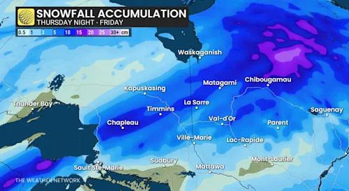
Baron - Northern Ontario snow through Friday - Jan 7
More potent system arrives Saturday
A strengthening Texas low will move across Ontario on Saturday, bringing significant moisture and varying weather impacts across the province. This system will deliver another round of rain to parts of southern Ontario, while high pressure from the north keeps temperatures below freezing, resulting in widespread snowfall for northern regions.
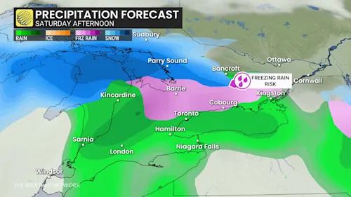
Baron - Ontario Saturday afterrnoon precipitation - Jan 7
Central Ontario is expected to see 10-20 cm of snow, though locations within this heavy snow band will be refined closer to the event. Residents in southern and eastern Ontario should also prepare for the possibility of freezing rain through Saturday afternoon and evening, with cold surface air in place.
WATCH: Barrie moves 21 Olympic pools' worth of snow this winter
Click here to view the video
Advertisement
Advertisement
Advertisement
Advertisement
As the system moves east late Saturday into Sunday, winds are likely to become blustery, causing blowing snow and reduced visibility in some areas.
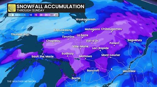
Baron - Northern Ontario snow through Sunday - Jan 7
Southern Ontario could see a quick burst of snow flurries as temperatures drop Saturday night into Sunday morning.
Potential flooding and ice safety concerns with this week's thaw
Snowbanks and snow depths in southern Ontario’s snowbelt regions are expected to diminish significantly as mild temperatures and rain arrive this week. The combination of snowmelt and rainfall could create localized flooding, particularly in areas where storm drains are blocked by snow. Residents should monitor for potential ice jams along rivers, which could exacerbate water levels, as well.
DON'T MISS: Many snowbanks in peril: Why a January thaw is a cause for concern
The warming trend may also lead to unsafe ice conditions on lakes and ponds. The rising temperatures could weaken ice cover and reduce its thickness, posing a risk for those venturing onto frozen water bodies.
Advertisement
Advertisement
Advertisement
Advertisement
The active storm track over the Great Lakes is set to continue into next week, bringing additional chances for snow and potentially messy weather.
RELATED: Is it safe? How thick does ice need to be to walk or skate on?
WATCH: January cold hits pause before winter stages a comeback in Canada
Click here to view the video
Stay with The Weather Network for the latest updates across Ontario.
تم ادراج الخبر والعهده على المصدر، الرجاء الكتابة الينا لاي توضبح - برجاء اخبارنا بريديا عن خروقات لحقوق النشر للغير