


اخبار العرب-كندا 24: الثلاثاء 6 يناير 2026 07:44 مساءً
All precipitation types will be on the table for Atlantic Canada with its next system on the doorsteps.
Heavy snow, rain, ice and freezing rain will be possible, depending on location. Anywhere from 5-15 mm of rain and up to 15 cm of snow is possible for some areas, while there could be ice accretion of 5+ mm in areas seeing an extended period of freezing rain.
RELATED: Freezing rain and ice pellets are dangerous winter hazards
Travel is likely to be impacted with messy road conditions.
Advertisement
Advertisement
Advertisement
Advertisement
Roads and walkways will likely be icy and slippery. Local utility outages are possible. Expect difficult, even hazardous travel in areas seeing heavy snowfall.
Another winter storm on deck for Atlantic Canada
On Wednesday, rain and snow move in from west to east by late morning through the afternoon.

Atlantic Canada precipitation forecast Wednesday overnight
A total of 5-15 mm of rain is possible for the New Brunswick south coast and Nova Scotia.
SEE ALSO: A winter storm's track can make or break your forecast
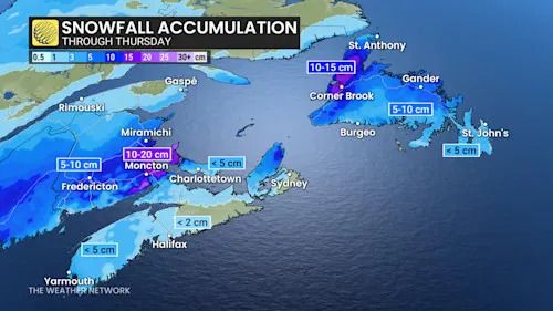
Meanwhile, 5-10 cm of snow is possible in central New Brunswick and northern P.E.I., and close to 10 cm for Fredericton, 15 cm for Moncton, and 15 cm north of Summerside, P.E.I.

Atlantic Canada snowfall through Thursday
Travellers can expect noticeable winter impacts to the Wednesday evening commute.
Advertisement
Advertisement
Advertisement
Advertisement
Flurries will linger in P.E.I. Thursday morning as the system moves into Newfoundland.
Newfoundland will see rain push into the Burin and Avalon peninsulas on Wednesday evening.
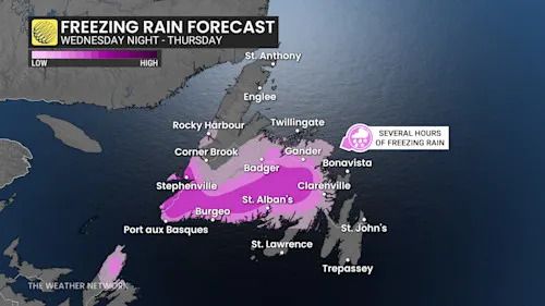
Farther inland, a classic freezing rain setup taking shape with warm air rising over the cold valleys.

Newfoundland freezing rain Wednesday night to Thursday
Prolonged freezing rain could fall for 10-12 hours into Thursday morning. Accretion of 5+ mm is possible.
As a result, drivers can expect slick conditions during the Thursday morning commute.
Also, a bout of 10-15 cm of heavy snow is forecast in the west and north ends of Newfoundland, lasting into Thursday morning. Expect difficult travel during that time.
Advertisement
Advertisement
Advertisement
Advertisement
Forecasters are watching for another system, a more significant and messy storm to arrive on the weekend. Snow and ice should quickly change to rain for the southern Maritimes. A slower transition is expected across Newfoundland with significant snow and ice. This should be a significant winter storm for northern New Brunswick, eastern Quebec and Labrador.
Temperatures will be somewhat changeable, but overall, well above seasonal through mid-January. Temperatures should trend closer to seasonal for the final 10 or more days of January.
Stay with The Weather Network for more information and updates on your weather across Atlantic Canada.
WATCH: What’s the difference between freezing rain and ice pellets?
Click here to view the video
تم ادراج الخبر والعهده على المصدر، الرجاء الكتابة الينا لاي توضبح - برجاء اخبارنا بريديا عن خروقات لحقوق النشر للغير