


اخبار العرب-كندا 24: الثلاثاء 6 يناير 2026 04:08 مساءً
January is typically the snowiest and coldest month of the year. It's the heart of winter, when seasonal fatigue is at its highest and all everyone can think of are the warmer months ahead. Luckily, an upcoming January thaw will bring folks across the country a welcome break from winter's cold wrath.
Temperatures are forecast to reach 10-20 degrees above normal in what is normally the coldest stretch of the year. After a cold and stormy winter so far, this will be a great chance for folks to get outside and enjoy the outdoors.

First time above freezing in January in Canada's Far North
However, warmer temperatures means melting snow, and parts of Canada have lots of it to melt.
Advertisement
Advertisement
Advertisement
Advertisement
The thaw is already being felt in Northern Canada, where temperatures in Alert, the country's northernmost station, reached 0.9°C on Jan. 6. This is the warmest January temperature recorded in the station's history, with records dating back to 1951.
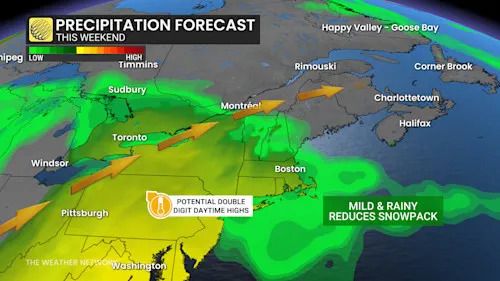
Eastern Canada sees warm side of winter this weekend
Another storm will rapidly intensify as it tracks from the south-central U.S to northern Lake Huron on Saturday.
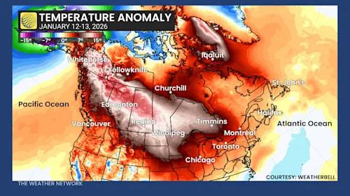
January thaw/temperature anomaly
With mild air from south of the border, the storm will bring in rainfall to southern Ontario, eastern Ontario, cottage country and southern Quebec.
10-20+mm of rainfall will briefly chip away at the sturdy, tall-standing snowbanks in Ontario's snowbelt communities.

Eastern Canada precipitation forecast this weekend
Several days pf above-freezing temperatures will extend all the way out to Atlantic Canada where daytime highs will be five to degrees above normal this weekend.
Advertisement
Advertisement
Advertisement
Advertisement
Southwestern Ontario has a chance to even see double-digit temperatures on Friday.
Milder Western Canada on deck next week
Meanwhile, in the West, mild Pacific air will be back on tap for late weekend and into early next week.
Forecasters are tracking a surge of Pacific moisture for central B.C., then emerging over the Rockies.
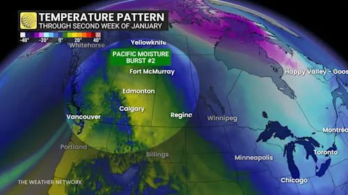
Western Canada temperature pattern second week of January
A significant warm-up will arrive in B.C., the Prairies and even Northwest Territories. The result will likely be a rise in freezing levels, unstable alpines, higher-than-normal avalanche danger, and snowmelt.
However, the warm trend likely won’t last with plenty of Arctic air lurking in the North.
تم ادراج الخبر والعهده على المصدر، الرجاء الكتابة الينا لاي توضبح - برجاء اخبارنا بريديا عن خروقات لحقوق النشر للغير