


اخبار العرب-كندا 24: الأحد 28 ديسمبر 2025 10:32 صباحاً
Hot on the heels of Ontario's Boxing Day storm, the atmosphere is primed to deliver another system in the form of a Colorado low.
A dynamic atmospheric setup combined with intense moisture to the south will result in a rapidly strengthening storm that will deliver a dangerous mess to much of Ontario.
SEE ALSO: The polar vortex is on the move! Canada's winter forecast update
The system will approach the Great Lakes on Sunday, possibly reaching 'weather bomb' criteria as the centre of the low rapidly intensifies.
Advertisement
Advertisement
Advertisement
Advertisement
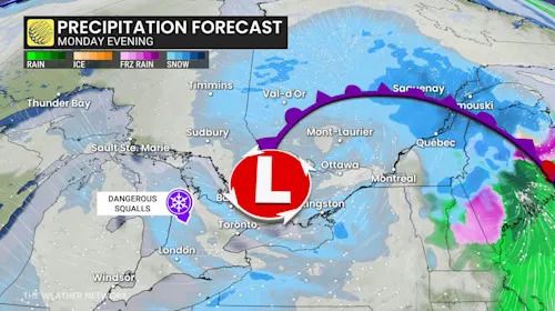
Blizzard conditions, an ice storm, and flooding rains are all possible in different corners of Ontario as this complex and hazardous system pushes through the province.
Prolonged freezing rain threatens the east
Eastern Ontario, including Ottawa, will contend with an ice storm beginning on Sunday. This event may produce 8-15+ hours of freezing rain, bringing 5-15 mm of ice accretion to the region.

Eastern Ontario forecast freezing rain accumulation through Monday - Dec. 28, 2025
Manitoulin Island and areas east of Georgian Bay are also likely to experience the prolonged freezing rain.
In addition to the slippery conditions this will create, winds are also forecast to pick up, which increases the risk of power outages as the ice builds up on trees and power lines.
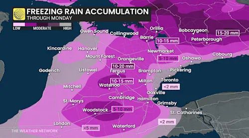
Southern Ontario freezing rain accretion
We will also see a period of freezing rain in southwestern Ontario that could lead to 5-10+ mm of ice accretion, especially at higher elevations.
Blizzard risk builds in the northeast
Strong winds and heavy snow over northeastern Ontario are forecast to bring whiteout conditions across the region into Monday morning. Areas east of Lake Superior are also at risk of seeing blizzard conditions, making highway travel downright dangerous, especially around Wawa, Chapleau, and Timmins.
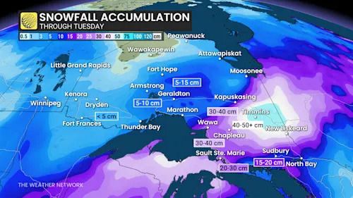
Northern Ontario forecast snowfall accumulation through Tuesday - Dec. 28, 2025
Areas hardest hit by the heavy snow could see up to 30-50+ cm by the time the storm passes. Folks should expect some road and highway closures.
DON'T MISS: Your winter storm preparation checklist
Those near and south of Sault Ste. Marie are forecast to see a bit of a wintry mix in addition to the heavy snow, impacting travel along Highway 1 toward Sudbury and North Bay.
WATCH: Winter storm brings blizzard conditions to northern Ontario
Click here to view the video
Heavy rains threaten flooding in southern Ontario
Warmer temperatures over southern Ontario paired with the high atmospheric moisture should bring heavy late-December rains to the region late Sunday.
Advertisement
Advertisement
Advertisement
Advertisement
While monthly rainfall averages across the south in December stay around 40-50 mm, we could see 50+ mm of rain locally north of Lake Erie, including the Grand River watershed, in a 12-hour period.
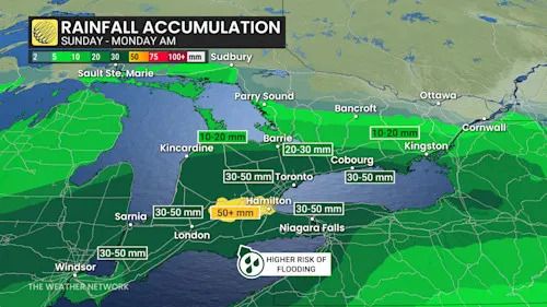
Southern Ontario forecast rainfall totals through Monday morning - Dec. 28, 2025
However, due to recent cold temperatures, the ground across much of the region is frozen, which will significantly limit the amount of rainfall absorbed into the ground and increase the risk of flooding.
Along the Humber River watershed, we're looking at the threat of ice jams due to repeated freeze-thaw cycles, increasing the risk of damaging floods.
Thunderstorms are also possible in southwestern Ontario as some instability inches into the region late Sunday through the pre-dawn hours Monday.
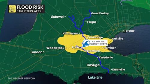
Southern Ontario watershed flooding risk - Dec. 28, 2025
Damaging winds, flash freeze risk builds Monday and Tuesday
After Sunday night's rainfall across southern Ontario, we will see a rush of cold air move into the region on Monday. Communities in and around Hamilton and Niagara could see temperatures drop by as much as 10°C in just one to two hours.
Advertisement
Advertisement
Advertisement
Advertisement
This is a red flag signalling the risk of a flash freeze as the ponding water on the ground and roads suddenly freezes up and forms a layer of slick ice.
RELATED: Winter storm aftermath: How to prevent ice dams and roof leaks
As the low lifts over Georgian Bay on Monday, we'll also see winds begin to pick up to damaging levels along the Great Lake shorelines.
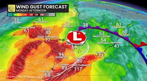
Ontario wind gust forecast Monday afternoon
Winds are forecast to blow southwest over Lake Erie, gusting between 80-110 km/h. The Niagara region will bear the brunt of this wind before it shifts to the northwest later in the day.
By late Monday, we'll see the winds gusting northwest off of Lake Huron and Georgian Bay, with peak gusts between 70-100 km/h.
Advertisement
Advertisement
Advertisement
Advertisement
The damaging winds will also persist on Lakes Erie and Ontario, as well as throughout Prince Edward County, despite the shift in direction.
Folks should be prepared for some power outages with these winds, as they could knock down tree limbs and damage power lines.
Waves could reach up to 5 metres on the lakes as well, with 6-8 metre waves possible on southern Lake Superior. Folks along the shores should keep an eye out for sudden ice shoves.

Ontario precipitation forecast Monday evening
The winds will continue through the night and into Tuesday. As temperatures continue to drop across southern Ontario overnight, lake-effect snow squalls could create whiteout conditions throughout the snowbelt regions.
Advertisement
Advertisement
Advertisement
Advertisement
As the gusty winds linger through Tuesday, we could see blowing snow continue to bring hazardous conditions for folks travelling to celebrate the New Year.
Stay with The Weather Network for more information and updates on this developing storm in Ontario.
WATCH: Storm hitting Ontario Sunday will bring another messy mix
Click here to view the video
تم ادراج الخبر والعهده على المصدر، الرجاء الكتابة الينا لاي توضبح - برجاء اخبارنا بريديا عن خروقات لحقوق النشر للغير


