

اخبار العرب-كندا 24: الخميس 18 ديسمبر 2025 08:56 صباحاً
A strong Alberta clipper sweeping the Prairies will make its final stop in Manitoba on Thursday, bringing dangerous blizzard conditions and near-impossible travel. On Wednesday, Alberta faced significant travel and flight disruptions due to the storm, while Saskatchewan saw multiple road closures and travel advisories.
RELATED: Calgary airport forced to pause flight operations as major storm hits Alberta
Another clipper is expected to follow a similar path, bringing additional snow to northern Alberta early Friday before moving east through central Saskatchewan and southern Manitoba later in the day.
Advertisement
Advertisement
Advertisement
Advertisement
Be sure to plan travel accordingly and stay up-to-date on the forecast and any weather warnings in your area.
Dangerous blizzard conditions in Manitoba Thursday
Blizzard conditions are lingering across southeastern Saskatchewan and southern Manitoba, continuing to create hazardous travel conditions, and road closures.
Wind gusts of 60-80+ km/h are forecast to continue in southern Manitoba throughout the afternoon. Brandon and Winnipeg could see additional snow accumulation during the day, with affected areas possibly reaching 10-20+ cm of total snowfall.
"Travel will be dangerous and likely impossible due to near-zero visibility. There may be a significant impact on rush hour traffic," says Environment and Climate Change Canada (ECCC) in a blizzard warning for Winnipeg. "Avoid travel and outdoor activities, if possible."
SEE ALSO: ECCC launches new colour-coded Canadian weather alerts
Conditions are expected to gradually improve across both provinces into the evening.
WATCH: Whiteout conditions hit southern Saskatchewan
Click here to view the video
Another system to bring more snow and dangerous travel Friday
A second Alberta clipper is forecast to follow a similar track early Friday, moving into northern Alberta before spreading eastward across central Saskatchewan and southern Manitoba later in the day.

Baron - Prairies Friday morning precipitation - Dec 18
This system could bring another 5-15 cm of snow along routes that have already seen heavy snowfall, including areas along the Yellowhead Highway and southern sections near the Trans-Canada Highway.
Advertisement
Advertisement
Advertisement
Advertisement
Expect blowing snow, whiteouts, and hazardous travel due to strong winds of 60-80 km/h accompanying the system.
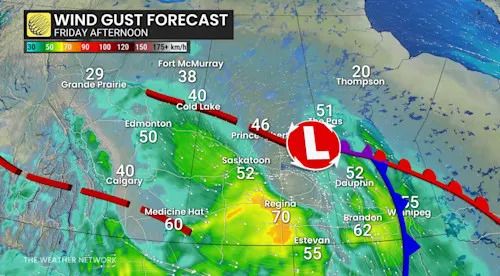
Baron - Friday afternoon winds Prairies - Dec 18
Dangerously low temperatures arrive Saturday
A blast of Arctic air will bring sharply colder temperatures across the Prairies by Saturday.
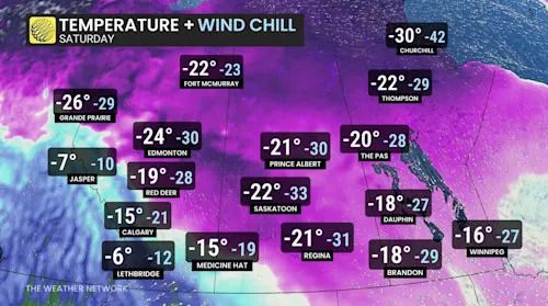
Baron - Prairie temperatures Saturday - Dec 18
Regions further north could see consistently frigid conditions, while areas near the U.S. border are forecast to experience fluctuating temperatures into next week.
WATCH: Snowy commute home for Edmonton with heavy snow Wednesday
Click here to view the video
Stay with The Weather Network for the latest on conditions across the Prairies.
تم ادراج الخبر والعهده على المصدر، الرجاء الكتابة الينا لاي توضبح - برجاء اخبارنا بريديا عن خروقات لحقوق النشر للغير

