


اخبار العرب-كندا 24: الأحد 14 ديسمبر 2025 08:32 مساءً
Prepare for significant disruptions across portions of Atlantic Canada as a powerful winter storm moves up the East Coast.
This system, which will rapidly strengthen as it approaches Newfoundland, will likely produce heavy snow and high winds along its track. Blizzard conditions are likely in some communities.
DON’T MISS: What turns a snowstorm into a raging blizzard?
Snow in the Maritimes through Monday morning
An intensifying low-pressure system tracking up the East Coast on Sunday night will create dangerous conditions heading into the day Monday.

Atlantic Canada precipitation Monday morning
The heaviest snowfall for the Maritimes is expected overnight Sunday and into Monday morning. Precipitation will ease by Monday afternoon.
Advertisement
Advertisement
Advertisement
Advertisement
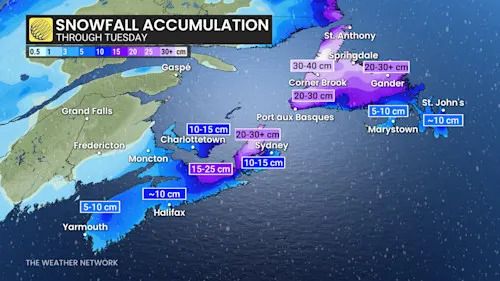
Winter travel impacts are likely Monday morning where 5-15+ cm of snow is likely. Heavier totals are in the forecast for western Cape Breton and regions bordering the Northumberland Strait.
Blizzard conditions likely across Newfoundland
Forecasters have high confidence in widespread heavy snowfall across western and central Newfoundland through Monday night.
Strong winds will develop as the low rapidly strengthens, with gusts peaking near 100-120+ km/h on Monday evening and into Monday night.
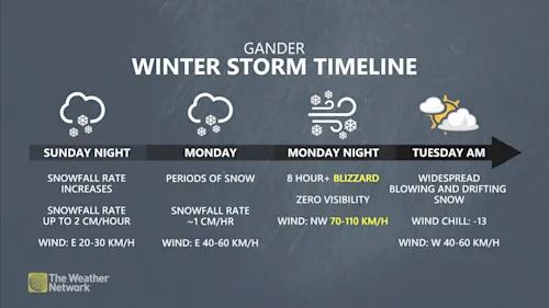
Gander winter storm timeline
The combination of heavy snowfall rates and intense winds will lead to a blizzard in central and northern Newfoundland. Communities including Gander, Grand Falls-Windsor, St. Anthony, and Twillingate could see up to 8 hours of blizzard conditions during this storm. 30-40 cm of snow will fall in the hardest-hit areas.
Advertisement
Advertisement
Advertisement
Advertisement
Farther east, communities on the Burin and Avalon Peninsulas can expect snow at the beginning of the storm. Precipitation will transition to a messy wintry mix early Monday, which will then swiftly change over to all rain as southerly winds drag warmer air into the region.

Atlantic Canada snowfall totals through Tuesday
We could see up to 10 cm of snow on the Avalon Peninsula before the precipitation change arrives.
Likely impacts include closures, outages
Areas expecting blizzard conditions will see little to no visibility during periods of heavy snow and strong winds. Anyone can easily become disoriented in near-zero visibility, even just venturing a short distance away from safe shelter.
Power outages and tree damage are likely amid the storm’s high winds.
Advertisement
Advertisement
Advertisement
Advertisement
Expect school closures and activity cancellations as a result of this storm.
Widespread travel delays are likely, including ferry delays and cancellations. Strong winds may easily exceed the safe operating limits of passenger flights into and out of the region, prompting additional delays and cancellations.
WATCH: When does a snowstorm become a blizzard?
Click here to view the video
تم ادراج الخبر والعهده على المصدر، الرجاء الكتابة الينا لاي توضبح - برجاء اخبارنا بريديا عن خروقات لحقوق النشر للغير