


اخبار العرب-كندا 24: الأحد 14 ديسمبر 2025 02:20 مساءً
The weekend in Atlantic Canada will conclude with a powerful storm that could bring heavy snowfall and blizzard conditions to parts of the region, with impacts continuing into this week.
The intensifying system will reach the Maritime provinces and Newfoundland on Sunday night. Anywhere from 5 to 40 cm of snow is possible, depending on locale, and wind gusts could hit 100-120+ km/h. Blizzard conditions are likely in parts of Newfoundland on Monday night.
RELATED: 'Weather bombs': Explosive storms that create ferocious conditions

Explainer: Weather bomb cyclone bombogenesis explainer (NEW FONT)
Forecasters are confident it will be classified as a weather bomb as models are showing a drop of 30-40 mb within 24 hours.
Advertisement
Advertisement
Advertisement
Advertisement
Similar storms in the past have caused: School closures and cancellations of community activities, disruptions to public services, and delays or cancellations of ferry services.
Heavy snow brushes the Maritimes Sunday night
Snow is expected to start Sunday night as the storm sweeps by Nova Scotia and Prince Edward Island, clipping portions of southern New Brunswick on the way to Newfoundland.
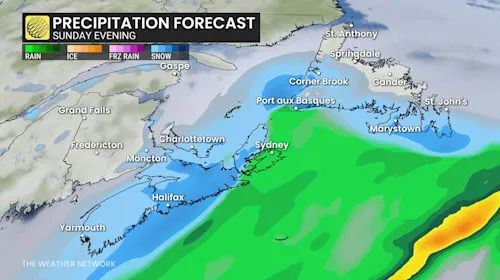
Atlantic Canada precipitation forecast Sunday evening
Some snow and mixed precipitation expected on Sunday with an initial, weaker low, ahead of the larger storm.
Out of the Maritime provinces, Nova Scotia is forecast to take the brunt of the snow, which will be heaviest heading into Monday morning.
Depending on how close the storm tracks to shore, we could see anywhere from 5-15+ cm of snowfall across the province, with the heaviest totals in the eastern section.
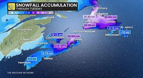
Atlantic Canada snowfall through Tuesday
SEE ALSO: La Niña to continue into 2026, leaving thumbprint on winter weather
Folks should brace for hazardous travel during the storm, which could result in school closures and cancellations of community activities, disruptions to public services, and delays or cancellations of ferry services.
System reaches Newfoundland Sunday night
The low-pressure system will continue to intensify as it reaches Newfoundland Sunday night.

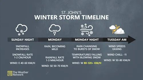
St. John's, N.L., winter storm timeline Dec. 14-16
Precipitation will start in the morning and persist throughout the day.
Advertisement
Advertisement
Advertisement
Advertisement
Western and central parts of the island will see the heaviest snowfall throughout Monday, while eastern portions of the island, including the Burin and Avalon Peninsulas, could see rainfall in the mix.
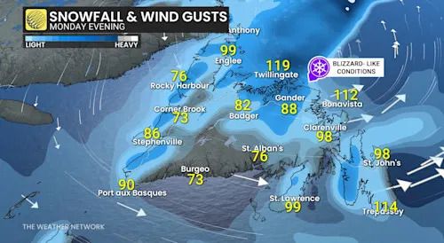
The greatest impacts are forecast to come through Monday as winds pick up from the intensifying low, gusting to 100-120+km/h, peaking in the evening and overnight.
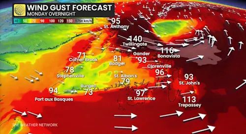
Newfoundland wind gusts Monday overnight
Combined with the snowfall rates, folks can expect poor visibility and high accumulations, with blizzard conditions likely Monday night as the powerful low lifts north of Newfoundland.
20-40 cm of snow is possible during the event across central and western Newfoundland. The Avalon is facing up to 10 cm of snow before the transition to rain early Monday.

Newfoundland snow and winds Monday evening
Eastern Newfoundland, including the Burin and Avalon peninsulas, can expect snow to start, but will transition to a messy wintry mix. Eventually, rainfall is forecast as the storm moves over the island Monday afternoon.
Stay with The Weather Network for more information and forecast updates for your weather across Atlantic Canada.
WATCH: How a 'Weather Bomb' forms and what it means
Click here to view the video
تم ادراج الخبر والعهده على المصدر، الرجاء الكتابة الينا لاي توضبح - برجاء اخبارنا بريديا عن خروقات لحقوق النشر للغير