


اخبار العرب-كندا 24: السبت 13 ديسمبر 2025 09:20 صباحاً
The weekend is set to end on a snowy, stormy note as a weather bomb makes its way up the East Coast late Sunday.
The intensifying system will track up the East Coast, reaching the Maritime provinces and Newfoundland on Sunday night. Anywhere from 5 to 40 cm of snow is possible, depending on locale, and wind gusts could hit 100-120+ km/h. Blizzard conditions are likely in parts of Newfoundland on Monday night.
DON'T MISS: Extreme cold on the move after Canada notches -50C reading
Currently, forecasters are watching the storm's barometric pressure drop fast enough that it could become classified as a weather bomb moving through the weekend.
Advertisement
Advertisement
Advertisement
Advertisement
The forecast is subject to change quickly depending on the system's track, which could take an unexpected turn offshore, so be sure to check back frequently to keep up-to-date on the current information.
Heavy snow brushes the Maritimes Sunday night
Snow is expected to start Sunday night as the storm sweeps by Nova Scotia and Prince Edward Island, clipping portions of southern New Brunswick on the way to Newfoundland.

Atlantic Canada precipitation forecast Sunday evening
Some snow and mixed precipitation expected on Sunday with an initial, weaker low, ahead of the larger storm.
Out of the Maritime provinces, Nova Scotia is forecast to take the brunt of the snow, which will be heaviest heading into Monday morning.
Advertisement
Advertisement
Advertisement
Advertisement
Depending on how close the storm tracks to shore, we could see anywhere from 5-15+ cm of snowfall across the province, with the heaviest totals in the eastern section.
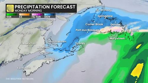
Atlantic Canada precipitation Monday morning
Commuters will want to keep a close eye on the forecast as it develops further over the weekend.
SEE ALSO: La Niña to continue into 2026, leaving thumbprint on winter weather
System reaches Newfoundland Monday morning
The low-pressure system will continue to intensify as it reaches Newfoundland Sunday night.
Precipitation will start in the morning and persist throughout the day.
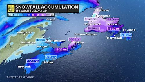
Atlantic Canada snowfall through Tuesday morning
Western and central parts of the island will see the heaviest snowfall throughout Monday, while eastern portions of the island, including the Burin and Avalon Peninsulas, could see rainfall in the mix.
Advertisement
Advertisement
Advertisement
Advertisement
The greatest impacts are forecast to come through Monday as winds pick up from the intensifying low, gusting to 100-120+km/h, peaking in the evening and overnight.
Combined with the snowfall rates, folks can expect poor visibility and high accumulations, with blizzard conditions likely Monday night as the powerful low lifts north of Newfoundland.
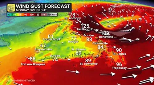
Atlantic Canada wind gust Monday overnight
20-40 cm of snow is possible during the event across central and western Newfoundland. The Avalon is facing up to 10 cm of snow before the transition to rain early Monday.
Eastern Newfoundland, including the Burin and Avalon peninsulas, can expect snow to start, but will transition to a messy wintry mix. Eventually, rainfall is forecast as the storm moves over the island Monday afternoon.
Stay with The Weather Network for more information and forecast updates for your weather across Atlantic Canada.
WATCH: How a 'Weather Bomb' forms and what it means
Click here to view the video
تم ادراج الخبر والعهده على المصدر، الرجاء الكتابة الينا لاي توضبح - برجاء اخبارنا بريديا عن خروقات لحقوق النشر للغير