


اخبار العرب-كندا 24: الثلاثاء 9 ديسمبر 2025 11:20 صباحاً
A very snowy and cold week lies ahead for the Prairies, so bundle up with extra layers and keep the snow-clearing equipment close by.
A few will traverse across the region, bringing a mix of wintry weather including heavy snow, freezing rain and showers. Winter storm and snowfall alerts are in place across parts of the Prairie provinces. Some areas could see 10-20+ cm of snow and wind gusts up to 90 km/h.
Consider rescheduling travel and outdoor activities. In the snow and blowing snow, visibility may be quickly and suddenly reduced to near zero. Road closures will be possible in the hardest-hit regions.
DON'T MISS: Arctic air on the loose: Who’s next in line for the freeze?
Once the snow exits the picture, folks on the Prairies will be contending with extreme cold and dangerous wind chills, with temperatures into the -20s and -30s for some areas.
This week: Winter weather will significantly impact travel
An active storm track will bring a series of Alberta clippers across the Prairie provinces this week. Winter storm watches have been issued across the southern Prairies.

Prairies precipitation timing Tuesday morning
A system that developed over southern Alberta Monday night will track into southern Saskatchewan on Tuesday.
Advertisement
Advertisement
Advertisement
Advertisement
There will be a very narrow band of contrasting temperatures, leading to periods of blowing snow, freezing rain and showers.
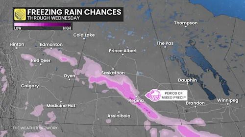
Prairies freezing rain chances through Wednesday
RELATED: City of Edmonton activates extreme weather response as frigid temperatures hit
The cold front will bring heavy rain showers or flurries into Tuesday morning, as well as strong, northwesterly winds gusting to 90 km/h for the southern Alberta-Saskatchewan border.
A narrow band of freezing rain is possible Tuesday morning, stretching from Kindersley to Estevan, Sask., including Regina, so expect travel difficulties, maybe even road closures.

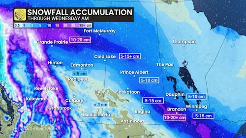
Prairies snowfall accumulation through Wednesday morning
SEE ALSO: Here are Canada's worst winter roads and the riskiest times to drive
"Visibility may be suddenly reduced to near zero at times. Road closures are possible," Environment and Climate Change Canada (ECCC) warns in the winter storm watch.
Advertisement
Advertisement
Advertisement
Advertisement
Snowfall is likely across southeastern Saskatchewan and southwestern Manitoba through the day on Tuesday, including the parklands. Exact accumulations remain uncertain given the narrow temperature contrasts, but a general range of 10 to 20+ cm is possible.
Another clipper will follow on Wednesday with snow in northern Alberta into Saskatchewan. Late Wednesday into Thursday will see another clipper move through southern Alberta and Saskatchewan.
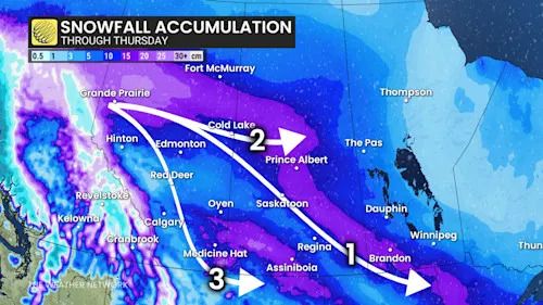
Prairies snowfall accumulation through Thursday
Meanwhile, snow bands will move in Wednesday overnight in Edmonton, then trekking south through Thursday morning and afternoon.
There is an uncertainty in the exact snowfall totals for systems occurring in the middle of and end of week.

Tue, Dec. 9: Prairies snowfall forecast
Forecasters have high confidence in 10-20+ cm of snow in northern Alberta this week, with a moderate confidence in 5-15 cm of snow in and around Saskatoon, to 10-20+cm in Brandon, Man., by Wednesday morning. The least amount of confidence exists for the end-of-week snowfall.
Bout of extreme cold to follow snow
Conditions will become frigid late week and into the weekend with severe and dangerous cold.
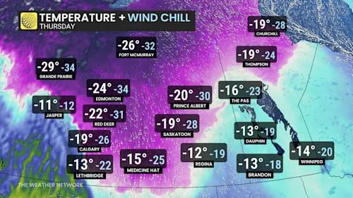
Prairies temperatures and wind chills Thursday
Temperatures will dramatically drop by 20 degrees for Calgary, with daytime highs of 1°C on Wednesday to -19°C on Thursday.
Advertisement
Advertisement
Advertisement
Advertisement
Daytime highs will remain stuck in the minus teens to -20s through the weekend.
Northern and central Alberta is already in the cold and snowy pattern, but it will get worse late this week. From Thursday night to Friday morning, temperatures will be close to -40°C in Edmonton, alongside dangerous wind chills.
An overnight forecast of -38°C at Edmonton airport, if it comes to fruition, would be its coldest value felt since the extreme -40°C stretch of cold in January 2024.

Prairies temperatures and wind chills Friday
Daytime highs will stay stuck in -20 to -30s for Edmonton through the weekend.
The severe cold will spread east into Saskatchewan and Manitoba on Friday. Saskatoon will remain near -30°C as daytime high.
WATCH: Frigid air spills onto the Prairies
Click here to view the video
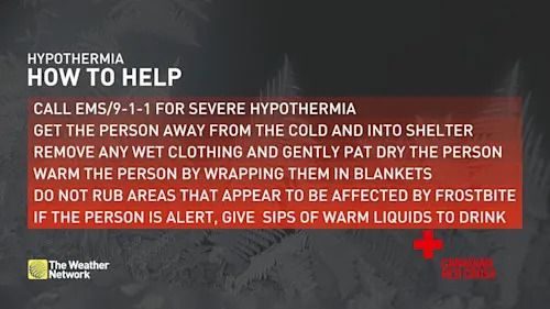
Cold weather safety
According to the Canadian Red Cross, it is important for everyone enjoying the outdoors to know how to recognize when someone has been exposed to cold for too long, prevent cold-related emergencies, and be able to provide help when needed.

Hypothermia safety explainer Baron graphic
Prevention tips include:
-
Cover your head and trunk by wearing a hat and layers of tightly woven fabrics such as wool or synthetics.
-
Cover up exposed areas such as your fingers, cheeks, ears, and nose.
-
If your clothes get wet when you are in the cold, change into dry clothes as soon as possible.
-
Drink plenty of warm fluids to help your body stay warm and hydrated, avoid caffeine and alcohol.
-
Eat high calorie food and drinks regularly as the body converts food to energy which heats the body.
-
Dress in layers so that you can adjust to changes as you heat up or cool off.
-
Bring additional warm clothing when going out for extended periods or in case of emergency.
-
Don’t wear tight fitting clothing or footwear that may impair circulation.
-
Seek shelter from the wind if you are getting cold, even if it is only behind a tree, hill, embankment, or other landscape feature.
WATCH: 'Worst year on record,' clothing donation centres struggle in Calgary
Click here to view the video
Be sure to check back for the latest weather updates across Alberta
تم ادراج الخبر والعهده على المصدر، الرجاء الكتابة الينا لاي توضبح - برجاء اخبارنا بريديا عن خروقات لحقوق النشر للغير