


اخبار العرب-كندا 24: الأحد 7 ديسمبر 2025 11:56 صباحاً
An atmospheric river will set off a train of soggy weather across southern British Columbia over the next week.
This robust atmospheric river could reach AR-2 and AR-3 intensity in B.C. as it washes over parts of the U.S. Pacific Northwest, too, as a AR-4 event.
DON’T MISS: Atmospheric rivers becoming so intense we need to rank them like hurricanes

Atmospheric river event (AR-3) B.C.
River flooding will be a concern with the persistent rainfall across the region.
Advertisement
Advertisement
Advertisement
Advertisement
As well, expect hazardous travel along the mountain passes as they face copious amounts of snowfall.
Moisture arrives this weekend and lingers into this week
This prolonged event will see multiple rounds of precipitation move into the B.C. coast over the next few days as a deep trough of air over the Gulf of Alaska directs heavy Pacific moisture toward the West Coast.
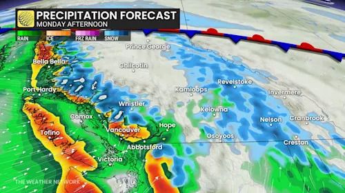
B.C. precipitation timing Monday
Moisture from southeast Asia will be the main source for this atmospheric river, although it will also merge with some moisture north of Hawaii as an added boost.
The atmospheric river moving into the West Coast on Monday will hit B.C. with AR-2 to AR-3 intensity, which means the region will see beneficial rains that could prove hazardous in spots. Folks south of the border in coastal Washington and Oregon could see significant flooding as forecasters expect the moisture supply to reach AR-4 intensity there.
DON'T MISS: Here are Canada's worst winter roads and the riskiest times to drive
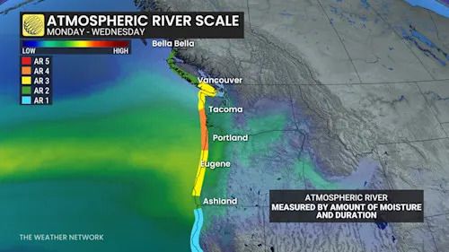
B.C. atmospheric moisture Monday to Wednesday
The Lower Mainland is on track for another 40-80+ mm of rain during the main event Monday through Tuesday. Lower rainfall amounts for eastern Vancouver Island, including Victoria as the strong northwesterly flow against the island's mountains protect the area from the heavy rains.
Advertisement
Advertisement
Advertisement
Advertisement
Given the prolonged and persistent rainfall moving into the region, residents are advised to watch for pooling and ponding on area roadways. River flooding is also possible as local waterways struggle to keep up with the excess runoff.
Luckily, a dry pattern over the past week will give some breathing room for the watershed.
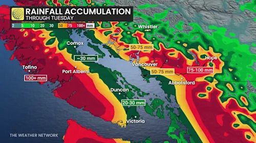
B.C. rainfall this week
Heavy alpine snow as freezing levels fall into next week
Freezing levels will be highly volatile this week, fluctuating between 1100-1800 metres, leading to heavy snow at times, leading to heavy snowfall over the Coquitlam and Allision passes. Drivers could see hazardous conditions as the heavy snow comes in pulses through late Sunday.
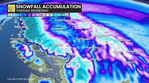
B.C. alpine snowfall through Wednesday
Freezing level spikes Monday afternoon and evening before dropping sharply Tuesday.
Advertisement
Advertisement
Advertisement
Advertisement
The North and Central Coast mountains could see 50-100+ cm of snowfall through the weekend and into Tuesday. 30+ cm of snowfall is forecast for the South Coast Mountains (above 1800 metres), and 20-40 cm is forecast for the Interior's Columbia and Rocky Mountains.
Stay with The Weather Network for the latest on conditions across British Columbia.
WATCH: Canada is getting its own atmospheric river rating scale
Click here to view the video
تم ادراج الخبر والعهده على المصدر، الرجاء الكتابة الينا لاي توضبح - برجاء اخبارنا بريديا عن خروقات لحقوق النشر للغير


