
اخبار العرب-كندا 24: الأربعاء 3 أبريل 2024 09:12 صباحاً
Click here to view the video
Strong winds and heavy rain have left much of southern Ontario dealing with the nastier side of spring this week. Special weather statements line the region for impacts from the potent storm set to continue through the day on Wednesday.
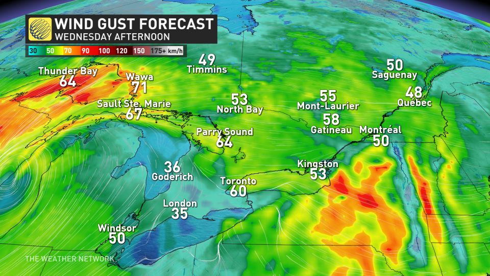
Travel and power disruptions are possible, as well as the potential for localized flooding. As much as 60 mm of rain is expected in some of the hardest-hit areas, as well as winds gusting up to 80 km/h, which could result in tree damage and scattered outages.

APRIL FORECAST: Canada faces a fickle April as winter wanes and summer teases
The rain is expected to change to snow as temperatures drop later in the day on Wednesday, though significant amounts are not expected across much of the south. The heaviest snow will fall across eastern Ontario and Quebec, where snowfall warnings are currently in place for as much as 20 cm forecast through Thursday.
Wednesday into Thursday: Winds and heavy rain continue, risk of wet snow as temperatures drop
April's first storm began to make its presence felt in Ontario Tuesday, with the wind and rain picking up through the overnight and early morning hours.
The rain will continue to intensify through the Greater Toronto Area (GTA), and north towards cottage country through Wednesday afternoon, with the chance for thunderstorms to bubble up across southern and eastern sections of the province, including the GTA.
REALITY CHECK: Snowfall is normal in April for Canada. Here are the averages
An additional 20-50 mm of rain is forecast for the hardest-hit areas by the time all is said and done, which could result in some ponding and pooling on roads, and localized flooding.
There won't be a widespread flood threat this time around, however, due to the lack of snowpack and lower than normal precipitation this past winter.
Winds will also remain high for the GTA, central, and northeastern Ontario, with gusts between 40-60+ km/h expected, before gradually subsiding later in the day.
Story continues
By the early morning hours on Wednesday, gusts in excess of 80 km/h had already been reported in the Toronto area.

SEE ALSO: Canada’s next solar eclipse could change the weather
Temperatures will begin to fall as the storm pulls in colder air from the north, and we'll see the rain transition to wet snow across higher terrain, with a band of accumulating, wet snow across northeastern and eastern Ontario.
Periods of wet snow will fill in across GTA and the south through the overnight hours on Wednesday, with all of the south transitioning to wet snow by Thursday morning.
Confidence in snowfall amounts is lower as temperatures hover around the freezing mark, however, some regions could receive between 5 to 15 cm, which could slick up the morning commute on Thursday.
Heavier snowfall amounts in eastern Ontario, including Ottawa
The heaviest snow threat builds in across eastern Ontario, where snowfall warnings are currently in place for 10-20 cm expected through Thursday. Travel delays are likely with the deteriorating conditions, and drivers in the Ottawa area are urged to pack their patience for this wicked blast of April snow.
DON'T MISS: Everything you need to know for April's spectacular and rare solar eclipse
Expect blustery and chilly conditions for a couple days as the system slowly departs the region, then a warming trend into the weekend with temperatures climbing well above seasonal.
Forecasters will continue to monitor conditions ahead of the total solar eclipse that’ll traverse the region on Monday, April 8.
Check back frequently for the latest on this evolving forecast over Ontario.
WATCH: Early signs point to hope for eclipse watchers in Canada
Click here to view the video
تم ادراج الخبر والعهده على المصدر، الرجاء الكتابة الينا لاي توضبح - برجاء اخبارنا بريديا عن خروقات لحقوق النشر للغير


