
اخبار العرب-كندا 24: الأحد 10 مارس 2024 01:46 مساءً
Click here to view the video
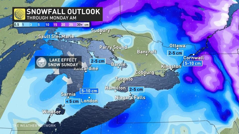
A Sunday drive may not be the best way to spend the final day on the weekend if you're heading out in parts of southern and eastern Ontario, as the lake-effect snow machine has been flipped on.
DON'T MISS: Everything you need to know for April's spectacular and rare solar eclipse
Snow squall warnings and winter weather travel advisories are in place, as some areas near Lake Huron and eastern Ontario could see 5-10+ cm of snow.
Travel may be hazardous due to sudden changes in the weather. Take extra care when walking or driving in affected areas.
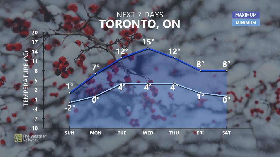
The good news is once the snow ends by Monday morning, we can expect to see a brief warming trend for the middle of this week, with the return of daytime highs more reflective April.
Sunday: Cold air forces a switch to snow for some
Northwesterly winds have settled into the Great Lakes, sending temperatures plummeting on Sunday and allowing the precipitation threat to switch from rain to snow.

Temperatures are cold enough to see a few snow squalls develop downwind of Lake Huron and Georgian Bay, targeting the traditional areas near those waterways.
HEADING TO FLORIDA?: Get your March Break travel outlook!
Sunday’s squalls could bring 5-10+ cm of accumulating snow to the traditional snowbelt communities, and locally 5-10 cm for areas east of Kingston.

Prepare to adjust travel plans if you have to drive through an area expecting snow on Sunday. Slick roads and lower visibility will make driving a challenge beneath the heavier snow squalls.
By Monday morning, the lake-effect machine will switch off and the snow will depart.
Early this week will see conditions on the cooler side of seasonal, temperatures will trend much warmer with well above-seasonal temperatures for a few days mid- and late this week with daytime values more typical of April. But, it will become unsettled at times as well with a threat for showers.

A much colder pattern is expected to develop around the official first day of spring, continuing through the end of March and into early April.
Story continues
Stay with The Weather Network for all the latest on your forecast across Ontario.
WATCH: How will your early flowers hold up as the cold returns to Ontario?
Click here to view the video
تم ادراج الخبر والعهده على المصدر، الرجاء الكتابة الينا لاي توضبح - برجاء اخبارنا بريديا عن خروقات لحقوق النشر للغير

