اخبار العرب-كندا 24: الجمعة 2 فبراير 2024 09:01 صباحاً

Click here to view the video
Despite the contradicting opinions from Shubenacadie Sam and Lucy the Lobster for Groundhog Day on Friday morning, there will certainly be no shortage of winter weather as we move through this first weekend of February across Atlantic Canada.
Significant snowfall and gusty winds will take aim at portions of the East Coast, with drivers being urged to plan ahead and brace for likely travel disruptions and cancellations.
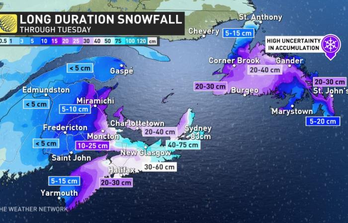
Some areas could see snowfall totals of 50+ cm with blizzard-like conditions with this extended period of high impact winter weather set to last into Tuesday.
MUST SEE: El Niño and the polar vortex take centre stage for winter’s final chapter
First round continues through Friday
A batch of snow that arrived in the Maritimes on Thursday will continue spreading east through the day on Friday.
Snowfall will build into Nova Scotia throughout the day, with a chance for mixing along the province’s southern coast.

The heaviest accumulations are expected in northern New Brunswick, where folks from Miramichi to Gaspé could see 15-20 cm of snow by the end of the system Friday.
Totals will stick closer to 5-10 cm in Prince Edward Island and eastern Nova Scotia. Lower amounts are likely where mixing occurs.
Significant snow could pile up through this weekend, and beyond
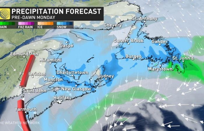
A second low-pressure system will develop south of Nova Scotia this weekend and slowly meander south of Newfoundland.

This stagnant pattern will bring the risk for persistent snowfall through the weekend and into early next week, along with the potential for gusty winds of 50-70 km/h.
Since we’re still a few days out and this is a complex setup, the exact track and local impacts are still uncertain. Folks across the region can expect an extended period of unsettled weather, including substantial snowfall totals for much of the eastern Maritimes and Newfoundland.

KNOW THE SIGNS: How shovelling heavy snow can lead to heart attacks
Forecasters expect the hardest-hit areas to include Cape Breton Island and the western and northeastern parts of Newfoundland. There is higher uncertainty for Newfoundland with less consistency in the computer models, but heavy snow is still expected to accumulate.
Story continues
Some of the hardest hit areas could see 20-40 cm of snow and blizzard-like conditions at times. Some computer models project locally higher totals of 50+ cm in some areas through Tuesday. This could be a significant storm for Prince Edward Island, as well.

The snow moves into southern and central Newfoundland through the day on Saturday, with periods of heavy snow later in the day. Light snow lingers on Sunday, but Sunday night through Monday is when the heaviest snow is expected for the island.
The Avalon will transition to mixing, and even some rain, which will help keep their numbers a bit lower, albeit still a good snow event.

Flurries linger into Tuesday, though becoming lighter.
Stay with The Weather Network and continue checking back over the next few days as forecasters nail down the details on this disruptive snowfall threat across Atlantic Canada.
Looking ahead, a few days of fair weather are expected during the middle of next week, though forecasters will closely watch the track of a large storm expected to move well south of the region near the end of the week.
Fear not, though, because there’s a glimmer of hope on the horizon if you’re tired of the cold and snow. Current trends suggest that temperatures will come in well above seasonal during the second week of February.
WATCH: What does February have in store for Canada?
Click here to view the video
تم ادراج الخبر والعهده على المصدر، الرجاء الكتابة الينا لاي توضبح - برجاء اخبارنا بريديا عن خروقات لحقوق النشر للغير


